
Landscape
Landscape Mainly works of art which I made in response to various landscapes that I encountered on my travels.
dated 2016 until 2025
(click on an image to enlarge an artwork)
send a message
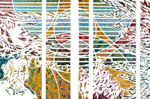
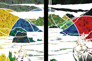
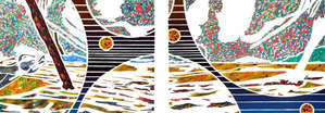
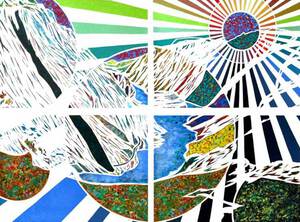
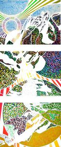
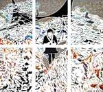
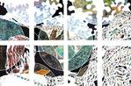
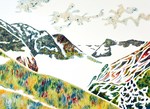
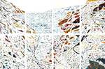
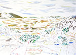
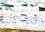
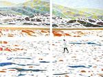
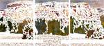
Nez de Jobourg 2025
2025Nez de Jobourg 2025

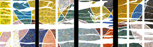
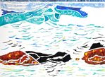
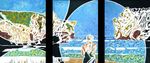
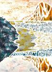
Yport
2024In the southern part of the Haute-Normandie region lies the charming seaside resort of Yport. The village is mainly known for its beautiful chalk cliffs and its pebble beach.

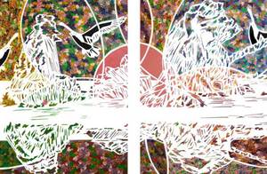
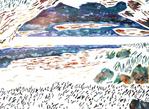
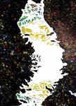
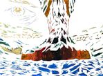
Dooagh 2024
2024Dooagh 2024

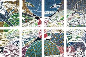
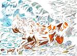
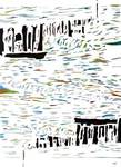
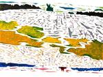
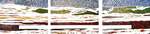
Cauesway coast 2024
2024Cauesway coast 2024

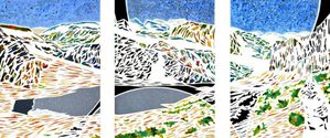
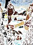
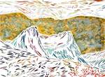
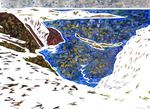
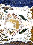
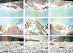
Malham Cove 2024
2024Malham Cove is a limestone formation 1 km north of the village of Malham, in the Yorkshire Dales in Northern England. The large, curved rock-face was formed by a 300 m wide and 80 m high waterfall that drained melting-water from glaciers at the end of the last ice age, more than 12.000 years ago. At the top of this rock-face an interesting limestone 'pavement' developed. When the glacier retreated, a flat, bare limestone bed remained upon the upper edge. Because limestone is slightly soluble in water, drainage along joints and cracks in the limestone produced an ever more distinct pattern. The stones are called ‘clints’ and the (sometimes deep) cracks ‘grykes’. When the grykes are fairly straight and the clints fairly uniform in size, the resemblance to man-made pavement is striking, and that is clearly the case here. This place was used in the film version of Emily Brontë's ‘Wuthering Heights’ from 1992 and in the seventh Harry Potter film (Harry Potter and the Deathly Hallows - part 1), as one of the spots that Hermione and Harry travel by.
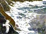
Coornagillagh Beach 2023
2023We are here at the Bay of Kenmare, between the southwest peninsulas of Ireland. These peninsulas, such as Dingle, Iveragh or Beara, have countless small natural harbors, which in the past were a paradise for smugglers. Daniel O'Connell was one of those smugglers, originating from Derrynane, which is a few miles away, and it is said that much of his family wealth came from smuggling. He is remembered in Ireland as 'The Liberator', a great activist for Irish independence. One of the main streets in Dublin, O'Connell Street, is named after him. We camp at Coornagillagh and at dusk we take a stroll to the nearby beach. A campervan has found a place here for the night, owned by a friendly French couple, whom we had met before on a very narrow mountain road in Dingle. Up there, their campervan had been badly damaged by the rocky edge of the road, so they were not very cheerful! But confronted with the beautiful sunset in this bay, their grief seemed to have faded away. I was figuring out how to capture this beauty, and in which colors.....
Bajo Fray Pêrez Spain
2022A view on the Atlantic Ocean, from Galicia in north-west Spain. This region was successively inhabited by Celts, Romans, Sueben and Vandals. Its capital is the famous pilgrimage site of Santiago de Compostela. The feudal system and the ecclesiastical hierarchy caused Galicia to fall further and further behind in economic terms, compared to the other Spanish provinces. As an example of this backlog, villages are mentioned that were deprived of electricity, even though the power plant stood next to the village for 20 years. The coast is of great beauty, but it can be rough at times. In 2002, Galician beaches were polluted by the oil tanker 'Prestige'. There was a lot of criticism on the Spanish authorities, who towed the ship to open sea, causing the pollution to spread even more. For the population, depending for a large part on fishing, the Prestige was a great disaster. Fishing boats from Galicia fish the entire Atlantic Ocean. The cultivation of mussels and other shellfish is also important. In recent years, the production of algae also plays an increasingly important role.
Tourmalet
2022The Col du Tourmalet is a mountain pass in the Pyrenees that owes its name to a flood of the river Gave in the eighteenth century. Because of this flood, traffic was forced to take this pass. The name 'Tourmalet' means something like 'bad detour'. Long before the mountain became known by the Tour de France, it was mainly climbed by pilgrims or by shepherds with their flock. In the year 1910, the 2115 meter high mountain was included for the first time in the route of the Tour de France. The French cyclist Octave Lapize was the first cyclist to reach the top and since then the ascent of the Tourmalet has been part of the Tour almost every year, often as part of the so-called 'Queen's Stage', the toughest stage in the Tour. We also chose this 'bad detour', and not for the first time, because we are always impressed by this special landscape.
Sømna
2021We are here at the water-side in the municipality of Sømna in the province of Nordland in Norway. In the distance across the water we see Torghatten mountain. This mountain is known for the huge hole that it contains: a natural tunnel of 160 m long, 20 m wide and 35 m high, which runs right through the middle! According to a legend, the hole was caused by a troll chasing a beautiful girl and shooting an arrow at her. But the troll king of this town Sømna, threw his hat (Norwegian: hatten) into the trajectory of the arrow to save her, and the hat turned into the mountain with the hole in the middle. I wonder if this is the spot where the troll king shot his arrow?
Torghatten
2021Torghatten is a mountain on the island of Torget in the province of Nordland in Norway. This is the fourth time we visit the island, but this time we decide to climb up the mountain to see if what is being claimed about this spot, is true....The mountain is known for the huge hole that it contains: a natural tunnel of 160 m long, 20 m wide and 35 m high, which runs right through the middle! According to a legend, the hole was created by a troll chasing a beautiful girl. When it turned out he couldn't obtain her, he shot an arrow at her to kill her. But the troll king of the nearby town of Sømna threw his hat (Norwegian:hatten) into the trajectory of the arrow to save her and the hat turned into the mountain with the hole in the middle. However, there are some who claim that the hole was created by erosion in the Ice Age...
Geiranger
2021We are looking out on the Geirangerfjord in Norway, which has been a Unesco World Heritage Site since 2005. It is 15 km long and has a depth of more than 600 meters. Far inland, at the end of the fjord, lies the village of Geiranger. Due to its depth, large cruise ships can moor in the port of Geiranger. The amount runs up to some 140 to180 each year, which increases the number of tourists on this spot to about 700,000 a year! When we got to this point we could just see that there were three large cruise ships docked, but soon a dense fog from the mountains entered the fjord, so we’ll have to settle for this image.....
Jøkelfjord 2021
2021Jøkelfjord is a fjord in northern Norway. This is where the Øksfjordjøkelen debouches, the 8th largest glacier on the Norwegian mainland and the only one of which the ice tongue reaches into the sea. The glacier covers an area of approximately 43 km² and the highest point is 1,204 m above sea level. This is also the highest point of the Norwegian province of Finnmark.
The Gulf of Trieste
2021A donkey brays over the coastal strip in this part of Slovenia. Under and between the trees we look out over the water of the Gulf of Trieste, which is part of the Adriatic Sea. The gulf covers an area of about 1000 km², with an average depth of 16 meters and a deepest point of only 37 meters below sea level. In the gulf there is a slow current spinning counterclockwise. Its coast is shared by Italy, Slovenia and Croatia. The northern half of the Adriatic is nowhere deeper than about 100 meters, while the southern half is more than 1200 meters deep.
The limit of
2020This happens to be the border at Državni Gozd, a border-crossing between Austria and Slovenia. In 2017 this frontier didn’t represent much anymore, but when I passed here in 1976, still rigorous controls were executed. In those days one passed from Austria to Yugoslavia, a country that was not part of Nato and also not part of the Warsaw Pact. But in this painting I’m not really concerned with this particular border, more so with boundaries in general. In 2019 (and actually already in the ‘70’s of course), we stumbled upon the climate boundaries. The question is whether humanity is able to survive if we don’t change our behavior in this respect. And now in 2020, we're confronted with another boundary: the Coronavirus that causes a global pandemic.
Lagos de Covadonga
2020Lagos de Covadonga These are the Lakes of Covadonga, two glacier-lakes in the Spanish region of Asturia. The Lago de Enol and the Lago de Ercina are also referred to as the Lagos de Covadonga. They are located at an altitude of 1134m in the mountains, and form the heart of the National Park Picos de Europa.
Park Picos de Europa
2020During the 1st and 2nd century BC, Celts settled in this region. They were known for their courage in combat and for their worship of natural elements. A distinguished deity was 'Mons Vindius', the 'white mountain', a reference to the limestone rocks that are found here. Sheltered by these gods of stone, the Asturians and the Cantabrians were invincible for a long time, until after ten years of rebellion, Roman emperor Augustus defeated them. 700 Years later, in the year 711, Arabs reached this region, and again the mountains gave protection to the local population. A small local army held out against the enemy for a long time, and eventually this led to the battle of Covadonga in the 8th century, in which the Arabs were conquered.
Pilotuerto, Spain
2020This is a view on the Reservoir of La Florida, also known as the reservoir of Pilotuerto, in Asturia, Spain. The 19m high dam and hydroelectric power station were built in the river Narcea in 1952.
Ruta del Cares
2020Located in the Picos de Europa National Park, in northern Spain, Ruta del Cares is one of the most breathtaking hiking trails you can walk in Europe. This 11 km long rocky path along the gorge of the River Cares, connects the small towns of Puente Poncebos and Posada de Valdeon, while offering stunning views all the way. The path is quite narrow, with rocks on one side and a precipice on the other. With a width of 1 to 3 meters, it is important to be careful if you have fear of heights. A minimum of fitness and good shoes are required. Every year, more than 200,000 people visit it, but in the last 20 years 6 people have also died. In the summer, especially in July and August and at Easter, the number of walkers can even be overwhelming! In 1999 we walked halfway through it from the West and then back again, in 2000 half the way from the other side. It's autumn 2016 and we set off once more. This time we notice that at our age, with a slower working balancing-organ, we find it somewhat scarier....
Praia de Valcobo
2019The waves of the Atlantic wash on the small stretch of beach of Praia de Valcobo in North-west Spain. The water splashes high against the boulders that lie scattered on the sand. Although this spectacle is constantly repeating itself, yet it differs with every wave…..
Punta Sarridal
2019This is a cape in Galicia in northern Spain. This coast is exposed to the intense breakers from the Atlantic Ocean and consists of rugged cliffs, occasionally interrupted by rocky beaches. The region is sparsely populated. Small villages and individual farms are mainly found in the valleys behind the mountain ridge along the coast. On the mountain ridge and the highland itself, open grass and heather vegetation dominate. In the sheltered valleys behind it grow dense forests, mainly composed of eucalyptus trees, with an undergrowth of ferns. Due to the unique bio-geographic conditions, several rare lichens also thrive.
Ouch, my toe
2019Near the village of Luarca in the Spanish province of Asturia lies the Playa de Portizuelo. Luarca is located between steep slopes on the Atlantic Ocean and has a small fishing port. Furthermore it lies on the Camino de Santiago pilgrimage route. At low tide, various beautiful rocks lie clear on the beach. The seawater has worn out whimsical shapes in the rocks with beautiful colors. For a photographer it's a great experience to go between the photogenic rocks, but in ones enthusiasm one should be careful where to walk....and then all of a sudden: ‘Ouch, my toe!’ A toe is stubbed against the rocks....
Col de Sarenne
2019The beautiful route over the Col de Sarenne, at a stone’s throw from the large ski area of the Alpe d'Huez, is rather unknown, so the area has a relatively intact environment. On the other hand the road surface is particularly bad, especially in the descent. When the Tour de France planned to come this way in 2013, the road was meant to be improved, after some cycling pros had stated that this Col amounted to a definite suicide. But local action groups and nature organisations protested and collected lots of signatures. They threatened to block the road during the Tour, with the result that only the very worst parts of the road were improved. And this undoubtedly contributed to the preservation of the beautiful landscape on the Col de Sarenne.
Playa de Cuevas del Mar 2019
2019I am standing on a small beach at the mouth of the river Cuevas in Spain. The beach is studded with huge rock-formations eroded by the sea, in which caves and tunnels are carved out. It is quiet and still in this beautiful karst-landscape. The term Karst refers to all the phenomena that arise from the dissolution of limestone in water. Limestone is left over from the skeletons of (sea-)animals. These landscapes once were an ocean floor or they’re still located near the sea. A karst-landscape originates when the soluble limestone is worn out by erosion, e.g. by acid rain, and the less soluble parts remain.
Andenes Norway 2018
2018The village of Andenes lies on the northern tip of the island Andøya, part of the Lofoten archipelago in Norway. It was already an important fishing village during the iron age. By the beginning of the 20th century it was one of the largest fishing ports of Norway. On the west side of the village are small coves with beautiful blue water and white sandy beaches, that look as if one has arrived in a tropical area. But no, this place lies far north of the Arctic Circle, facing the North Atlantic, from where an ice cold, strong wind is blowing inland ....
Aurland Norway
2018Aurland is a municipality in the Sogn og Fjordane county in Norway, located on the Aurlandsfjord. Via the Lærdaltunnel, which is, with its 24.5 km, the longest road tunnel in the world and through a dozen small tunnels with hairpin bends, one steadily rises on the mountain slope, until finally, in one of the turns, a view on the deep and narrow Aurlandsfjord is revealed (under water 962m deep and surrounded by steep mountains up to 1800m altitude). But also on a huge forest of power lines that run into the valley and disfigure the highlands above. There is an ancient story that in prehistoric times a battle was going on between two groups of trolls, causing the land to break into pieces. After Wodan collected the rocks with which they harassed each other in a bag and emptied it over Sweden, he sewed the land together again with these wires. Frankly I think they’re just power lines, providing electricity for e.g. the city of Bergen.
Bleik
2018Bleik, on the island of Andøya has the longest sandy beach (3 km) of Norway. Behind this beach lies a terminal moraine, a glacial till that was left behind by the ice sheet during the last Ice Age. Bleik is situated on one of the few extreme points of Norway that were not fully covered with land ice during this ice age. Terminal moraines are formed at the edges of glaciers. Towards this point, all the debris that is collected by the pulling and scraping of the ice, is pushed forward and dumped on a heap. The moraine marks the end of the ice and because the glacier behaves very much like a conveyor belt, the longer it exists, all the greater the quantity of the deposited material will be.
Ersfjord
2018This fjord is a bay on the island of Senja in the province of Troms in North Norway. Apart from Svalbard, Senja is the second largest island of Norway, next to the island of Hinnøya. Nowadays Senja is connected to the mainland by the - more than a kilometer long – Gisund-bridge.
Higher Sharpnose Point
2018This is the view from the narrow path that runs over the cliffs of Higher Sharpnose Point to Hawker's Hut, near Morwenstow on the west coast of Cornwall (GB). The historic hut was built by Robert Stephen Hawker (1803-1875), an eccentric preacher, poet and antiquarian. He built the hut of drift-wood and wood from shipwrecks, partly in the hill and covered it with soil and a grass-roof. Parson Hawker spent many hours there writing poems, receiving famous contemporaries and smoking opium.... It is currently the smallest property owned by the National Trust. At the foot of these cliffs innumerable small rocky spits of land stretch out in the Atlantic Ocean, they are referred to as 'point', 'nose' or 'head'.
Hjelledalen
2018From Djupvatnet, a large lake on a plateau not far from the famous Geirangerfjord in Norway, one finally arrives after a couple of long tunnels under the mountain area of Strynefjellet, in Hjelledal. A thick layer of clouds lies over this valley surrounded by glaciers, ice caps, mountains and rivers. The climate here is as varied as the landscape. On the East side of the Jostedals-glacier it is cold and dry during the whole winter, whereas the Ottadal valley, situated on the North side and in the 'rain shadow' of the mountains, is wet and extremely fertile.
Storøya
2018Since 1969 a series of three bridges connect the islands Storøya and Hallvardøya in the Efjord in North Norway with the mainland. Several times a day powerful tidal currents flow between the islands. The longest bridge, the suspension bridge between the mainland and Storøya is 551 m long and has 15 spans with a maximum height of 18 m above the sea. The second bridge, between Storøya and Hallvardøya, is the smallest: 143 m long and 15 m above the sea. The third bridge connects Hallvardøya again with the mainland and is 162 m long. The mountain on Storøya. looks like a crater, worn away or fallen down on one side.
Seaweed
2018On the coast of Gimsøy, one of the islands of the Lofoten Archipel in Norway, well known for its rich fishing tradition, waves are playing with this seaweed. Seaweed is a relatively large type of algae, living in the oceans and executing photosynthesis by using chloroplasts. They need salt water, enough light and a solid surface to attach to. Therefore they usually occur along the coast. In the Netherlands seaweeds are found on a depth of a few meters at the most, due to the fact that our seawater is not bright enough to transmit enough sunlight at greater depths, but under favorable conditions seaweed can reach lengths of 60 meters. Kelp (a large Brown Alga) forms, together with many other species, the so called kelp-forests.
Col de Puymorens
2017Autumn reigns on this mountain pass, the Col de Puymorens in the Pyrenees. This pass, with a height of 1920 meters, is the connection between Spain, France and Andorra. Before Andorra became the tax-free capital of Europe and before French and Spanish citizens were seduced en masse to come and fill their cars here, this route over the Puymorens probably was a quiet mountain road.
Jostedalsbreen 2017
2017In 2015 we are here for the third time. The donkeys have been replaced by motorized carts, utilized mainly by Japanese tourists. We already noticed three large cruise ships that moored in the Oldenfjord. By now it is an even further walk, but finally we arrive through a natural tunnel that we hadn’t noticed previously, in a wide open valley and yes, the Jostedalsbreen is there once again! We just witness a large piece of ice breaking loose and falling down from the glacier tongue. There is no way to come closer to the ice, it hardly reaches halfway down the steep mountainside. It is clear that climate change asserts its influence here. By now the Briksdalsbreen looks like the other glacier tongue we saw in 1998 from the campsite. The question is whether our children or grandchildren, if at anytime they consider to follow in the footsteps of their grandparents, will even see a glacier, and if they won't say: well, our grandpa always had these kind of stories and way too much imagination, he also used to say there was a crocodile in the pond, while that pond had a cross-section of just one meter!
Nordkapp
2017After a journey through Sweden, Finland and Norway on a beautiful sunny day you come in to the North Cape. Do you ride for €60 by the toll booths to the official car park, or you walk to the edge of the Cape with the Arctic Ocean in depth? We opted for the latter. At about 300 m depth you see the ice cold water against the coast. From here it is only 2080 km to the North Pole, but we do not anyway, first by the cold water and then over the ice seems to me just go too far, but who knows in the future .... ever. The North Cape is not the northernmost tip of the whole of Europe, that is Cape Fligely on the Franz Josef land archipelago, which belongs to Europe and approximately 600 km north of the North Cape. The North Cape is also not the northernmost point of mainland Europe. Even when you're small islands not included, is it something eastly Kinnarodden actually the northernmost tip.
Ornolac Ussat Les Bains
2017Ornolac Ussat Les Bains is located near Foix in the Midi-Pyrénées in France. The region called Midi-Pyrénées was composed, not until the late 20th century, by the French Government of as many as eight former provinces. Thus it became the largest region of France, larger than the Netherlands or Denmark. The area includes the southern part of the Massif Central in the North, as well as the Pyrenees as its southern border.
Skånvika Nordkapp
2017After a journey through Sweden, Finland and Norway, we arrived on a beautiful sunny day at the North Cape. The question is whether we will we pass the toll booths to the official carpark for €60 (!), or walk to the brink of the Cape right there, with the Arctic Ocean down below? We chose for the latter. At about 300m depth the ice cold water dashes against the coast. From here it’s only 2080 km to the North Pole, but that is something we won’t do. To cross the cold water and after that the icecap, but that would be carrying things too far for now, but who knows, somewhere in the future .... The North Cape is not the northernmost tip of the whole of Europe, that is Cape Fligely on the Franz Josefland archipelago, which belongs to Europe and lies approximately 600 km north of the North Cape. It is even not the northernmost point of the mainland of Europe. The actual northernmost tip is Kinnarodden, the Nordkinn Cape, lying a bit more east on the Nordkinn peninsula.
Varangerfjorden
2017Blocs of marble lie here on the coast of the Varangerfjord in the far north of Norway, within the Arctic Climate Belt. The Varangerfjord is the easternmost fjord in Norway (just as Eastern as Istanbul!) and borders Russia, noticeable by the Russian-Norwegian street signs. The fjord is about 100 km long and is an estuary of the Barentz Sea. The coastal landscape varies: there are sandy beaches, but also lunar landscapes and special mountain formations with small fishing villages in between.
Cromer
2016This stretch of North Sea beach lies near the coastal village of Cromer in Norfolk (GB). The origin of the place-name Cromer is uncertain: it could mean ‘crows mere’ (or lake). But there are other contenders for the derivation, a north country word 'cromer' meaning 'a gap in the cliffs'. I didn’t notice a gap in the cliffs, but all the more the wooden breakwaters on the shore. They seem to do their job well, but nevertheless the town was affected on the 5th of December 2013 by a storm surge that caused significant damage. Likewise the original village called Crowmere-Shipden, about a quarter of a mile to the north east, was swallowed by the sea in the 15th century. For a long time the engulfed village was marked by a rock in the sea called ’Church Rock’, but at the end of the 19th century that was blown up for safety, after a vessel suffered shipwreck on it. Furthermore this shore is considered to have one of Europe’s largest chalk reefs and therefore designated as a marine conservation zone.
Gordale Beck
2016This brook, the Gordale Beck, flows through the famous limestone ravine the Gordale Scar, northeast of Malham in North Yorkshire, England. After its passage through the gorge it ends a few miles downstream in the river Aire. The Gordale Scar has two waterfalls and overhanging limestone cliffs with a height of more than 100 meters. This scar was formed in the last ice age, by massive amounts of water from melting glaciers and a collapsed cave. The place strikes the imagination, and was often celebrated and recorded by artists such as painter William Turner or the poets William Wordsworth and Thomas Gray.The latter said he could stay at the utmost a quarter of an hour here, and 'not without shuddering’. For me this is going a little too far, although indeed we experienced it as a intriguing place when we stayed here overnight. When I started this work, it felt like we were overlooked back then, so I painted an eye in the sky.
Gordale Scar,
2016When you pass the Gordale Beck, the stream that flows through this valley in North Yorkshire in England, the path around a corner suddenly turns out to be a blind road (except for more experienced climbers).It ends on a waterfall plunging its water over large boulders in an immense basin of rock walls, which appears to be a collapsed cave: the Gordale Scar. What does this remind me of? It looks like Helms Deep from 'The Lord of the Rings'! That’s not possible because that movie was filmed in New- Zealand. But after some research I discover that indeed Tolkien has gained the inspiration for Helms Deep right here! Along this brook, apart from the Gordale Scar, lie also: Janet's Foss, a waterfall where according to the legends, Janet the Queen of the fairies had her home and Malham Cove, an 80m high limestone rock-face, crowned by a natural limestone pavement.
Coast Marbella
2016In the 1960's and ‘70's this former fishing village with its 26 km long beach turned into a large holiday resort and the popular holiday destination for millions of tourists. The whole coast has developed into one long tourist centre, with high apartment-buildings, hotels and shopping centers that sometimes need renovation by now, which is not always possible due to the current crisis. The rich as well as many celebrities have their cottages in the hills, secluded from the rest of the world. But less than ten kilometers from the coast one can also discover a totally different world: authentic white villages and a beautiful countryside with mountains, gorges, caves and a lush flora that gives the Costa del Sol a unique character.
Llivia
2016Llivia is a Spanish town high up in the Pyrenees, that is completely enclosed by France. Around 1660 the Spanish/French border was redefined and 33 formerly Spanish villages, including Llivia, were to become French territory, until the Spaniards discovered that Llivia had city rights and consequently was not covered by the contract. Since then it was an enclave. The city was already inhabited around 3000 BC. On the coat of arms Hecules is depicted, the founder of the city according to legend. Hercules was the son of the supreme God Zeus and princess Alkmene, who was married to Amphitryon. Zeus tempted her by disguising as her husband, after which she gave birth to a twin: Hercules (of Zeus) and Iphicles (of Amphitryon). But Zeus' wife, the goddess Hera, was jealous of the adultery of her husband and sent two horrible snakes to the crib, which however were strangled by the extremely strong prodigy Hercules. Also Zeus wanted Hercules to obtain eternal life, by having him breast-fed by Hera. But when she found out, she made sure that the milk was spilled and that spilled milk formed the Milky Way.
Malham Cove
2016Malham Cove is a limestone formation 1 km north of the village of Malham, in the Yorkshire Dales in Northern England. The large, curved rock-face was formed by a 300 m wide and 80 m high waterfall that drained melting-water from glaciers at the end of the last ice age, more than 12.000 years ago. At the top of this rock-face an interesting limestone 'pavement' developed. When the glacier retreated, a flat, bare limestone bed remained upon the upper edge. Because limestone is slightly soluble in water, drainage along joints and cracks in the limestone produced an ever more distinct pattern. The stones are called ‘clints’ and the (sometimes deep) cracks ‘grykes’. When the grykes are fairly straight and the clints fairly uniform in size, the resemblance to man-made pavement is striking, and that is clearly the case here. This place was used in the film version of Emily Brontë's ‘Wuthering Heights’ from 1992 and in the seventh Harry Potter film (Harry Potter and the Deathly Hallows - part 1), as one of the spots that Hermione and Harry travel by.
Mealt Falls
2016This area is located on the North East coast of the Isle of Skye in Scotland. Between 61 and 55 million years ago, much volcanic activity took place in this part of Scotland. Both the Cuillin mountains in the South of Skye and this northern part of the peninsula of Trotternish were then formed. The whole area was covered with a lava-sheet of more than 1200m thick. When the lava slowly cooled down, it found its way over an older sandstone layer from the Jura. Thus outstanding basalt-pillars were formed, resting on a sandstone base. One of these is the beautiful 90m high ‘Kilt Rock’, which strikingly resembles a pleated Scottish kilt. When a strong wind blows, there is a creepy, haunting sound to be heard. The instrument that produces this sound, turns out to be the fence surrounding the look-out. So the breathtaking view of the North-East coast of Skye is accompanied by intriguing organ music!
Porsanggerfjord
2016Porsanger has a population of almost 4000 inhabitants, many of whom have a Sami background. In the 18th century also many people settled along the Porsanggerfjord, who fled from famine and war in Finland in those days. These people are known today as Kven. The name of the Porsangerfjord originates from the Sami words borsi, which means waterfall, and angr, which means fjord. In terms of length, this is the fourth longest fjord in Norway. A little west of the fjord and the village of Lakselv, lies Stabbursdalen National Park, with the northernmost pine forest of the world. Here the midnight sun stays above the horizon each year from 16 May to 27 July and the polar night lasts from 25th November to 16 January.
Skibotn
2016This painting is a ‘nine-tych’, it measures a total of 2.25 x 3.00 meters. Here, in Norwegian Lapland, not far from Tromsø, where an offshoot of Finland almost reaches the Atlantic Ocean, the sun no longer sets in summer. This fjord at low tide, near Djupvik, about 50 km north of Skibotn in a bee-line, overlooks the Lyngfjord (or in Sami: the Ivgovuotna) and the high mountains of the Lyngfjellan peninsula. This region is known for its dry climate and clear skies. For that reason an astrophysical observatory was built in Skibotn.
Sorbas
2016One can almost feel the heat in this desert near the town of Sorbas in the province Almería in Spain. Because the landscape and climate are similar to the landscape in the Southwest of the USA, some western-cities were built here in the 1960 's, where spaghetti-westerns such as ‘The good, the bad and the ugly' or 'For a fistful of dollars' were filmed. Here you will also find the underground caves of Sorbas. They are located in the nature reserve ' Karst and Yesos the Sorbas ', a few kilometres outside the town. The caves, with precipices, stalactites and stalagmites, were created by water erosion. 1500 Caves are mapped over an area of 12 km2, one of the largest cave networks in Europe. In the summer there are guided tours.
Tangham Forest
2016Tangham Forest is the name of a campsite at Rendlesham Forest in Suffolk. Although only two plots on the whole campsite were occupied, we were ordered to a specific spot, correct to the cm, which was an amusing experience as such.... Around the campsite, old oaks grow in the so called ‘Ugly Wood'. Though freakish, I didn’t find them ugly, on the contrary: in the evening sun these interesting trees were beautifully lit! It seems there was a marked path nearby to a famous UFO-site. It turns out that in 1980 strange lights were observed on the Royal Airforce Base Woodbridge, which at the time was used by the US Air Force as well. USAF staff, including Deputy Commander Charles Halt, claimed to have seen UFO’s. This incident is the most famous UFO observation in Britain and even belongs to the most famous alleged UFO incidents worldwide. It has been compared to the 'Roswell'-UFO incident in the United States and is sometimes referred to as ‘Britain's Roswell’. Unfortunately we haven’t observed any UFO’s but we did see interesting oaks and a pig.
Teruel
2016Teruel is a province of Spain in the autonomous community of Aragon. There live in this province an average of 10 people per km2, which is almost the lowest population density in the whole of Spain. It is a mountainous area and it has a very dry climate, with temperatures up to 20 degrees in a few hours time. Highest and lowest measured temperatures are +39 ° C and-19 ºc. The economy must be the focus of the growing of cereals and tourism. And the sale of raw ham, but that's up to me.
Yorkshire Dales
2016The Yorkshire Dales are a hilly landscape in the North of England, mainly located on the eastside of the watershed by the Pennine mountains. After heavy rainfall its small streams turn into wild swirling rivers. The characteristic landscape of the Dales consists of dark hilltops and steep slopes, green valleys and highland meadows, separated by stone walls and grazed by sheep and cattle. The Dales are U- and V-shaped valleys formed by glaciers, particularly in the most recent Ice Age. The underlying rock is limestone, sometimes alternating with shale and sandstone. Especially on the westside of the Dales, this resulted in limestone gorges and majestic towering peaks and a number of spots with so called 'limestone pavement'.